As I ponder the 100th anniversary of the Izaak Walton League’s successful campaign to establish the Upper Mississippi River National Wildlife and Fish Refuge, I ask myself a few questions.
Why can’t we let the river do what it does naturally, and manage itself? Why do people have to intervene? How do we find a balance between many competing interests and a healthy river?
In short, how do we take care of our old friend, the Mississippi?
Growing up on the river
It’s funny how growing up on the Mississippi our relationship with the river is like family. We think of it like an aging friend—old, wise, a few wrinkles here and there, but a respected part of our lives. And we take it for granted. We know
the river ages and changes. That’s what rivers do.
But we also know, like many an aging friend, that a tuck around the eyes, a little botox here and there and a dose of that magical wrinkle cream gives the appearance of a being less worn.
Starting with the 1986 Water Resource Development Act, the Mississippi has received a great deal of tucks, prods and botox, all in the form of habitat restoration or rehabilitation projects. We The People—taxpayers—have spent over a billion
dollars trying to save or restore our beloved, aging friend. We’ve spent additional millions to study and monitor our dear friend, to help understand its ways, its changes, its tantrums, all to help better ensure that it continues to serve in
the same manner it has for the last couple hundred years. Our friend has done so much for all of us, and especially me.
Early uses and abuses
The native Americans valued the river. It was sacred. It gave life, it provided a foundation for their agriculture, it provided fish, furs and transportation. Our local native villages along the Upper Mississippi, if groups of 15,000 people can be called
a village, had extensive marsh agriculture. They trapped and fished, and their children played along the banks. They traded along well-established routes up and down the river all the way to the Gulf of Mexico.
By the early 1900s the river was cluttered with the trash of civilization. It was the great sewer of the Twin Cities and every major city development all along its length.
I remember a neighbor found a plumet, a tear-drop-shaped piece of obsidian, used as a weight on a circular net, thrown into the water to catch fish. The plumet, I learned from local archaeologists, came from somewhere down along the Gulf. Wow, what it
must have been like trading, canoeing, bringing goods to others and buying theirs to enrich life along the Upper River.
Then the Europeans came, and the world changed. We all know the stories. The native way of life was replaced by wagon trains, steam-driven paddle wheelers and the plow. I read an estimate that at the peak of steam boating there were 700 boats on the river
from St. Louis to the Twin Cities. Each boat consumed an average of 30 cords of wood per day, or about the amount of wood from harvesting 2.5 acres of forest.
We can estimate that during that time approximately 1,750 acres of forest needed to be cut each day to meet the steamboat demand for wood. Or you can figure about 420,000 acres of forest were harvested between the April-to-November steamboat season. That’s
a lot of wood to cut from the river and its banks. It was big business and just one of the enterprises the river supported in its early years as a commercial corridor opening the Midwest to agriculture, industry and European settlement.
Industry and human populations also took their toll as they dumped their waste and chemicals into our dear friend. By the early 1900s the river was cluttered with the trash of civilization. It was the great sewer of the Twin Cities and every major city
development all along its length.
Growing up in Winona, Minnesota, was a blessing. Our section of the Mississippi was one of the cleanest reaches along the entire upper river, thanks to Lake Pepin. The lake slowed the water, turning it more into a lake than river. All the upstream sewage
and most chemicals settled in the lake, returning our river to a clean, or at least swimmable, friend.
Thankfully, cities and industry cleaned up their act with the construction of the Pigs Eye treatment plant in St. Paul back in 1938. Large-scale clean-up started after the passage of the Clean Water Act in 1972 as point sources and municipal sewage were
managed, and the river began to clean itself.
However, the plow was not so easily managed.
The plow was the great nemesis
Slowly our old friend began to change as it lost its natural dynamics to move, erode, build and generally maintain itself as a great natural river system.
Swiss, Germans, Scandinavians and a few Poles got off the steamboats at places like Holmes’ Landing, today’s Fountain City, Wisconsin. They moved into the steep valleys of the Driftless region, that area glaciers did not scrape flat in western
Wisconsin, southeastern Minnesota, northeastern Iowa and northwestern Illinois. The area was and still is beautiful and dramatic: huge bluffs, limestone cliffs, forest and prairie, fresh spring water bubbling from the ground everywhere. It was heaven.
The new arrivals settled, built cabins and began to plow. In the early days, a team of horses and a plow could work far up a steep hillside. Even today we can walk in the woods and see the line where the plow once had turned our rich soil into river bottom
following heavy rains or the spring thaw.
Yes, the great agricultural invasion not only tamed the land and the people, but it also converted the landscape from prairie, forest and wetlands, to plowed field and pastured hillsides. And the river began to suffer. During the 1930s, following massive
erosion across our landscapes and accompanying flooding, the great agriculture conservation movement began. The people farming the land saw the need for change and they met that challenge. They started working with federal, state and county conservation
programs, changing how they farmed, implementing contour plowing and building small runoff dams to mitigate flooding. They began to keep cattle from grazing the sensitive hillsides.
Our river responded. It improved, cleaned up, and it began to store away all that farmland sediment in its backwaters and marshes. But the plow and municipal growth had another impact on our friend. It became a major commercial corridor, shipping goods
up and down the river to the growing cities, industries and farms. Coal and fertilizers moved up the river while agricultural products like grains, corn and beans moved down the river.
But river navigation on our old friend was a dangerous business, with the average life expectancy of river steamboats only four or five years. Boats running aground and fires were common. The government responded and began to manage our old friend.
Managing a force of nature
In 1829, the Department of the Army (through the Army Corps of Engineers) started its first river management program. They sent steamboats up the river plucking out trees and snags from the channel, removing obstacles that were threats to commercial traffic.
But it wasn’t enough.
In the late 1800s, the government began maintaining first a four-foot navigation channel to improve navigation, and then a six-foot channel. They did this by building rock and willow “wing dams” and “closing dams.” Wing dams are
rock structures built by piling rocks on willow mats, building the structure up so it rises just above the water level. They were built perpendicular to the shore into the river, forcing the water into the navigation channel, scouring and maintaining
a four-foot depth. The closing dams were the same type of construction, but they were built across side channels to force more of the river flow into the main channel to maintain the depth.
Over time, they built more and more of these structures pushing more water down the main channel. This had a great impact on our old friend. Reduced backwater flows changed floodplain dynamics. It isolated backwaters and marshes where sediment from agricultural
runoff began to accumulate. And slowly our old friend began to change as it lost its natural dynamics to move, erode, build and generally maintain itself as a great natural river system.
Then came the big change.
 Pool 7 of the Upper Mississippi River near Trempealeau, Wisc. Wing dams are evidenced by the rippling water in the river channel as they direct the flow to the main channel.
What spurred the League to act
In the early 1920s, the government proposed converting the river from Lake Pepin to the Quad Cities into a series of agricultural levee districts. The idea was to build levees along the main channel and drain the wetlands behind the levees to create massive
new agricultural areas. The maps were made, and they began talking easements.
The first proposal was drainage of the Trempealeau River bottoms, which was a failure as remembered in the poem by Mr. O.F. Immel, “The Voice of Trempealeau Marsh.” This was a devastating concept that rang the warning bells for those who loved
our dear friend, the Mississippi. It led Will Dilg to write “The Drainage Crime of a Century” in Outdoor America when the next project, the drainage of the Winneshiek bottoms, was proposed.
That warning motivated Will Dilg, one of the Izaak Walton League’s founders, into action. Dilg and his friends had spent summers on houseboats in the Winona, Minnesota and Lansing, Iowa areas, cultivating their love for the outdoors, the river and
fishing for black bass. And tragically, Dilg’s young son drowned in the river during one of those trips.
Alerted about the development proposal, Dilg realized the government’s plan would forever change the Mississippi from a diverse floodplain habitat to a channelized river with massive agricultural developments. He made the Izaak Walton League the
voice to protect the river.
Then in 1924, unbelievably, after the League’s fierce campaign, its vision was realized. The drainage project was stopped, and Congress created the Upper Mississippi National Wildlife and Fish Refuge, protecting the river, its wildlife and especially
its fish like the bass. In the 1950s the League erected a monument to Dilg, commemorating his epic battle, the creation of the League and the loss of his son.
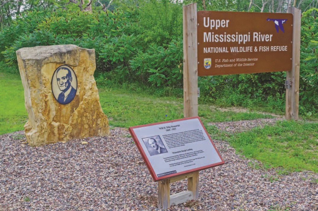 The League, led by Will Dilg, convinced Congress to establish the Upper Mississippi River National Wildlife and Fish Refuge in 1924.
Locks and dams
As navigation and agriculture expanded, the demand for larger and deeper vessels increased. The government responded with a plan to build a series of locks and dams to establish a nine-foot navigation channel. Major Charles L. Hall, working in the Army
Corps of Engineers chief’s office, was assigned to assess the feasibility of the nine-foot project.
Hall, to the shock of all the project supporters, recommended against the project in a report to the Chief of Engineers in August, 1928. He believed the project was economically inadvisable. Moreover, Hall concluded that the project would have disastrous
environmental impacts, stating the project would transform the free-flowing river into a series of interconnected lakes.
Echoing the concerns of Midwestern conservationists, Hall feared that these “slack-water pools would create vast swamps of stagnant and polluted water.” But the locks and dams were built, and the river responded (at least initially) to the
new habitats in a wonderful way. Habitat became diverse with a mix of backwater lakes, marshes, deep and shallow water. Wildlife responded and the migration corridor for waterfowl and other migrants also flourished. It was wonderful to see everyone,
including our old friend seem so happy.
By the mid-1970s, several things began to change. Sand from the main channel dredging began to fill in the backwaters. Islands, which were part of the river landscape for 5,000 to 10,000 years, were eroding away. The deep parts of the lower river pools
behind the dams were filling in, and backwater marshes and lakes began to change. The lower pools, which for millennia were typified by channels, lakes, islands, and marshes, changed to large, shallow, open lakes.
Massive amounts of sediment, nutrients and chemicals continue to dump into our river.
A group of researchers from several universities— Saint Mary’s, Winona State and University of Wisconsin-La Crosse—received contracts from the Corps and U.S. Fish and Wildlife Service to study the river and document what was happening.
The government also funded the first-ever color aerial photography survey of the Upper Mississippi to create a vegetation and landcover map of the river in 1975.
As a young new Saint Mary’s graduate student, I was so excited to be working and leading studies on my family’s old friend. I remember measuring fish in Weaver Bottoms, mapping vegetation with the new aerial photography and working with many
other teams from our partner universities to study flow, fisheries, productivity, wildlife and generally documenting how our old friend was doing.
But alarm bells began sounding. The researchers told the Corps in 1975 that they were witnessing a major change in the river’s ecological health, based on the aerial photography and river research. They petitioned the Corps for major changes.
At the same time, the federal and state agencies implemented a series of studies and changes to river management. They began putting dredged material in large containment sites on the river. But our old friend continued to decline.
In 1986, Congress responded to a call from the public and river resource management agencies by creating the Environmental Management program, a $33 million annual program to begin restoring our old friend.
Where we are today
Here we are more than 35 years later, having spent over $1.3 billion. We’ve increased the budget for the Environmental Management program to $55 million annually, and starting in 2021 the government appropriated funds to launch the multi-billion
dollar Navigation and Environmental Sustainability Program. Many organizations cheered. They waved the flag of restoration, touting all the great things being done to save our old friend.
The river faces huge challenges that will require bold steps and new generations of stewardship.
How is our overreliance on restoration as the primary response working? Wetland drainage and agriculture development continue to negatively affect much of the river’s land use. These uses eliminate the land’s ability to hold and store water,
and the soil’s resilience to store carbon and provide a healthy foundation to grow crops. Massive amounts of sediment, nutrients and chemicals continue to dump into our river, impacting not only the Mississippi, but also the Gulf of Mexico.
Due to agricultural nutrients coming down the river and into the Gulf, large areas of coastal habitat are dead zones, with low oxygen levels that kill aquatic life.
We also witness continued backwater sedimentation. Many sloughs, marshes and lake complexes are no longer navigable in a small motorboat. River levels have increased due to rising river bottoms and changing precipitation patterns that deliver more rain
in the watershed.
This has resulted in massive floodplain forest die-offs across multiple pools in the Upper Mississippi. You can drive the river road from Minnesota to Iowa and witness massive expanses of dead forest, their roots flooded as sediment raises backwater bottoms
and increased runoff from heavy rainfall and ever improving agricultural drainage raise water levels. The Corps proposal is to use river dredged material to raise the islands then replant the forest to “restore” the ancient islands. You
see, the large disposal sites created up and down the river in the late 1970s are full, they were planned for a 50 year life.
So, what do we do? During the ‘70s river biologists, friends of our dear River, rallied to stop backwater filling from river dredging. Now, the Corps and many of the river managers embrace dumping dredged river sand into the backwaters to “restore”
our dear friend. Have we embraced amputation to solve a simple disease?
Today, much of the natural floodplain forest has died or is dying. The plan is to use dredged main channel sand to raise the floodplain islands one or two feet. Barges will deliver sand and fine organic slough material as “top dressing” on
the raised islands. Trees will be planted to “restore” the forest. I wonder how well trees will grow on sand, and what would our friend think?
Bold Action Is Required
The Upper Mississippi River National Wildlife and Fish Refuge is an enduring example of how we can and must take action to save the nation’s waterways and ensure a future with clean water. We will need bold steps and new generations of stewardship
to address a range of problems—pollution, sedimentation and invasive species to name a few. Immediate steps we can take to help the Mississippi include improving the soil and water conservation practices in the Farm Bill, which Congress
is looking at now.
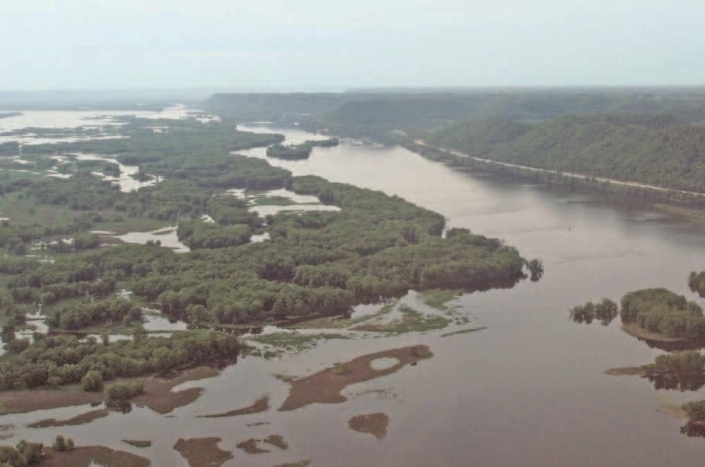
Top photo: The Refuge established in 1924 preserved many scenic viewscapes along the River. Credit: Steven Marking.
Learn more about the Upper Mississippi Refuge